Website content other than annual reports last updated May 31, 2013.
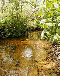
Photo Credit: URI Watershed Hydrology Lab
Areas with low impervious cover (<10%) have streams that can support a wide array of plants, macroinvertebrates, and fish.
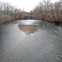
Photo Credit: RI Department of Transportation
In the Narragansett Bay Region, impaired streams are found in areas with high impervious cover. When impervious cover is over 25%, streams are severely impacted. This is a picture of the Woonasquatucket River above the Dean Street Bridge in Providence.
Learn More!
- Town-by-town data
- Explore the data using the RI Digital Atlas or MA Online Data Viewer
- Report on Reducing IC
- Mass Audubon: Losing Ground. Beyond the footprint: Development patterns and their impact on the nature of Massachusetts
- RI Stormwater Design and Installation Manual
- RI Stormwater Solutions
- Massachusetts DEP Stormwater
Data Sources:
- RIGIS
- MassGIS
- An Assessment of Impervious Surface Areas in Rhode Island by Yuyu Zhou and Y.Q. Wang (pdf)
- Economic Policy Council's 2006 Community Development Scorecard (pdf)
Note: Data for this indicator are only available every several years, so we won’t see the extent of recent changes for a few years.
Posters:
- 2013 Assessment Poster (pdf)
- 2011 Assessment Poster (pdf)

Impervious Cover
Impervious Cover (IC), such as roadways, driveways and roofs, has a large impact on our environment. These hard surfaces don’t allow rainwater to soak into the ground, where it would naturally be filtered and recycled into the environment. Instead, rainwater runs off into stormwater drains heading to rivers, ponds and to the bay, carrying pollutants, warming rivers, closing beaches, and worsening flooding downstream.
14% of the Narragansett Bay watershed is under impervious cover. Within RI, IC by municipality ranges from 3% to 40%. Scientists have observed a relationship between IC and stream quality. As a rule of thumb, streams surrounded by less than 10% IC are sensitive, vulnerable to degradation by increased development, between 10 and 25% are impacted, showing clear signs of degradation, and when IC is over 25% streams are severely impacted and can no longer support a diverse stream community. Only 17 towns in the state have less than 10% IC. Impervious cover increased 43% between 1972 and 1999, six times faster than population growth in the state. (Zhou & Wang, 2007)
Impervious Cover: 2011 Assessment
Status and Trends: The Narragansett Bay watershed has 14% Impervious Cover (IC), and this will increase with further development. IC is regional, very high in urban centers, lower in rural areas.
Management: The legislature has shown leadership on managing storm water and state agencies have taken implementation seriously. DOA’s urban services boundary directs new development to urban areas, and we are implementing strategies for minimizing IC as rural development occurs and retrofitting to manage storm water in our urban areas.
This map shows impaired rivers and streams (in red) with impervious cover (yellow is the highest) in the Narragansett Bay watershed. Many of the impaired streams are in areas with high IC.
Workshop Documents (in Adobe Acrobat format)
Presentations
- IC as an indicator used by other NEPs by Lesley Lambert (NBEP)
- IC and Watershed Management by Scott Millar (RIDEM Sustainable Watersheds)
- IC and Water Quality by Katie DeGoosh (RIDEM OWR)
- IC in the Narragansett Bay Region by Paul Jordan (RIDEM)
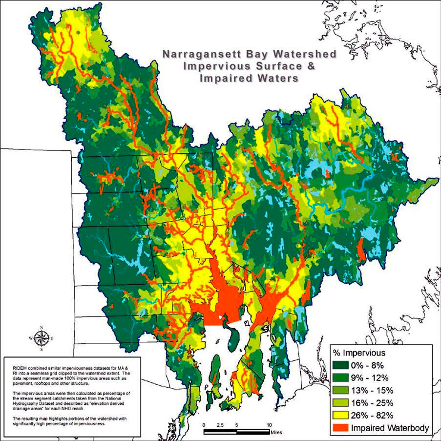
Map Credit: Rhode Island Department of Environmental Management